


PERRY TWP DIST 01, Fayette County, Pennsylvania
About
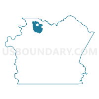
Outline

Summary
| Unique Area Identifier | 659700 |
| Name | PERRY TWP DIST 01 |
| County | Fayette County |
| State | Pennsylvania |
| Area (square miles) | 13.45 |
| Land Area (square miles) | 13.18 |
| Water Area (square miles) | 0.27 |
| % of Land Area | 98.02 |
| % of Water Area | 1.98 |
| Latitude of the Internal Point | 40.07138180 |
| Longtitude of the Internal Point | -79.74857500 |
Maps

Graphs
Select a template below for downloading or customizing gragh for PERRY TWP DIST 01, Fayette County, Pennsylvania


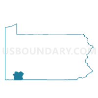
Neighbors
Neighoring Voting District (by Name) Neighboring Voting District on the Map
- FRANKLIN TWP DIST 01, Fayette County, PA
- FRANKLIN TWP DIST 02, Fayette County, PA
- JEFFERSON TWP DIST 01, Fayette County, PA
- LOWER TYRONE TWP Voting District, Fayette County, PA
- PERRY TWP DIST 02, Fayette County, PA
- PERRY TWP DIST 03, Fayette County, PA
- PERRYOPOLIS Voting District, Fayette County, PA
- WASHINGTON TWP DIST 02, Fayette County, PA
- WASHINGTON TWP DIST 03, Fayette County, PA
Top 10 Neighboring County Subdivision (by Population) Neighboring County Subdivision on the Map
- Washington township, Fayette County, PA (3,902)
- Perry township, Fayette County, PA (2,552)
- Franklin township, Fayette County, PA (2,528)
- Jefferson township, Fayette County, PA (2,015)
- Perryopolis borough, Fayette County, PA (1,784)
- Lower Tyrone township, Fayette County, PA (1,123)
Top 10 Neighboring Place (by Population) Neighboring Place on the Map
Top 10 Neighboring Unified School District (by Population) Neighboring Unified School District on the Map
- Uniontown Area School District, PA (23,820)
- Belle Vernon Area School District, PA (18,925)
- Frazier School District, PA (8,015)
Top 10 Neighboring State Legislative District Lower Chamber (by Population) Neighboring State Legislative District Lower Chamber on the Map
Top 10 Neighboring State Legislative District Upper Chamber (by Population) Neighboring State Legislative District Upper Chamber on the Map
Top 10 Neighboring 111th Congressional District (by Population) Neighboring 111th Congressional District on the Map
Top 10 Neighboring Census Tract (by Population) Neighboring Census Tract on the Map
- Census Tract 2601, Fayette County, PA (5,591)
- Census Tract 2602, Fayette County, PA (4,336)
- Census Tract 2603, Fayette County, PA (3,798)
- Census Tract 2611, Fayette County, PA (2,556)
- Census Tract 2610, Fayette County, PA (2,528)